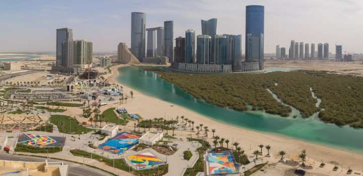
Hive Droneport : Autonomous Drone Station
HIVE DRONEPORT
The Future of Drone Autonomy Is Here
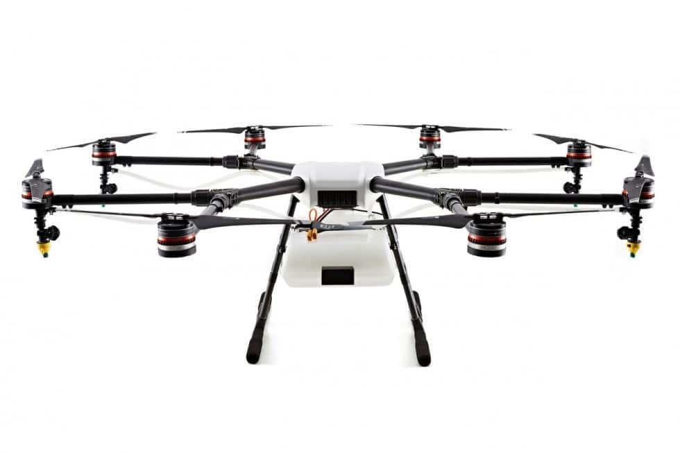
HIVE is a fully automated drone station capable of 24/7 continuous and autonomous operations.
Unlike other solutions, Hive’s advanced robotics auto-swap batteries for the drone to be ready to fly again within minutes and without the need to wait for recharging.
-
Auto-changes batteries (after one minute, the drone is ready to fly again)
-
A built-in security module and climate control
-
24 / 7 / 365 operation

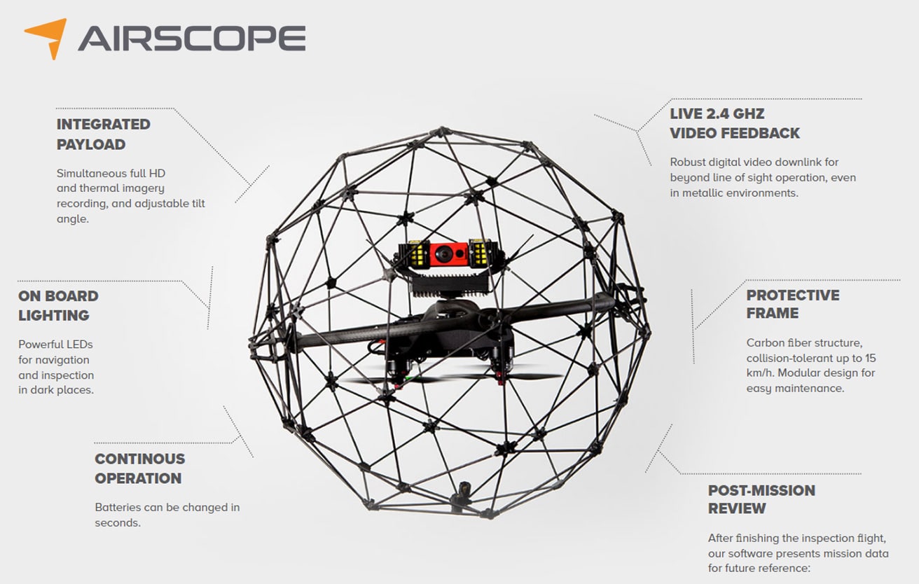
Airscope is the Official Partner for Hive
-
Control from anywhere
-
10 km2 /2,500 Acres area coverage
-
Suitable for any climate
-
Advanced AI
- Weather station module
- Weather station wind vane
- Security camera
- Omni-directional Wi-Fi antenna
- Security camera, directed towards maintenance door
- Landing table Infrared spotlight
- Directed 3G/4G antenna
- Brackets for equipment
- Save time thanks to the fast reaction to any incident: one station can immediately deploy aflight in case of an incident within the perimeter of 100 sq.km.
- Do not waste critical minutes during search and rescue operations: The drone is ready to be deployed after 1minute of battery swap.
- Reduce the risk of evidence contamination due to immediate deployment to a crime scene or accident location.
- Ensure 24/7 crowd control to ensure safety at large public events.
- Implement 24/7/365 control protocols for border and troubled areas to help prevent and detect crime.
- Decrease flight cost by at least 200% compared to the cost of helicopter flight.
- Increase operational efficiency by mapping large areas in 2D to generate actionable insights.
- Extend crime fighting capability by using AI, zoom and thermal cameras.
- Decrease time between flight authorization and drone deployment to the accident location.
- Anti-vandal housing and security module
- Internet module and quick access to cloud service
- Integrated weather stations
-
Manual mode and remote control
- Temperature and humidity management inside the station
- Hot-swap battery system and integrated charging station
UAV FEATURES
- Effective flight radius – 10 km2, area of coverage from 1 base station is 100 Km
- Payload -LIDAR, thermal cameras, professional cameras, photogrammetric camera
- Equipped flight time – 45 mins
- Operating temperatures from -30 to +40
- Fully autonomous flight with the possibility of interception in operator control by flight center from anywhere in the world
- Advanced system of security and sensors obstacle detection


CLOUD BASED REMOTE DRONE OPERATIONS
- Highly Secure
- Real Time 4G/5G Connectivity
- Cloud Based / Access From Anywhere.
- Intuitive Controls / User Friendly
- Pre Programmable Mission Modes
- Gimbal and Zoom Control
- Live Video Feed
- User Levels and Restrictions
- Custom AI Integrations
ARTIFICIAL INTELLIGENCE
Powerful edge computing and AI capabilities enable intelligent data analysis and recognition of potential incidents in the real-time video stream.
Object Detection
Image-Based Object Detection And Classification With Neural Networks
Detection Modules
Real-time notifications when a certain type of object appears in the field of view of the camera.
Real-time streaming
Automated Data Upload
Automatic Data Collection And Archiving By Edge Computing And 4G Connection
DEPLOYMENT

Construction

Infrastructure
Remote Locations

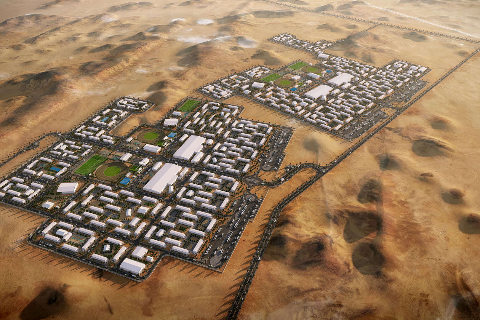
Smart City

Assets and Facilities

Mining
Airscope News
Reality Modelling for Shurooq
Communication Tower Inspections
Inspection Work with 30X Zoom
AquaDam Construction Reporting
Contact Us
+971 (0)4 423 4982
+971 (0)50 705 7213
info@airscope.ae
213 Detroit House,
Motor City 36587
Dubai, UAE
Follow Us
OUR CREATIVE NEWS..


Drone Surveys and Aerial Inspections - Airscope Industrial
Next Generation Drone Solutions For Old Problems
Certified
When it comes to Drone Survey & Inspections we maintain very high operational standards by ensuring that all our personnel are certified by relevant aviation authorities.
Insured
In addition to careful preflight planning, and risk assessment, we ensure that our team and equipment are covered by a minimum of USD 5,000,000 Third Party Liability Insurance.
Innovative
Our in-house research and development department enables us to provide our clients with innovative and autonomous aerial solutions for the real estate, energy & infrastructure sectors.


Better Technology: Better Analysis
Using the latest industry grade UAS technology, we are able to perform flights with multiple sensors, including 30x Optical Zoom, FLIR, NDVI & LIDAR
Instant Information & Decision Making
Using the Airscope asset management software, you can view, record and share live drone inspection feeds & data in real time. This allows managers and engineers to save time and make quicker decisions.

Professional Drone Services for Architecture, Engineering, and Construction.
Reality Modelling for Shurooq
Communication Tower Inspections
Inspection Work with 30X Zoom
AquaDam Construction Reporting


Through continuous research and development, we strive to set the highest standards in the remote inspections industry.
Mohammed Aziz. CEO,
Airscope.
INDUSTRIAL SERVICES
Inspections
Survey
Thermography
Tethered Drone Solutions
Multi Spectral Imaging
Reality Modelling
Consulting
R&D
Reporting
Geospatial
Panoramic Photography
Drone Permits
Drone Training
INDUSTRIAL SECTORS
Oil & Gas
Flare Stack Inspection
Pipeline Inspection
Tank Inspection
UnderDeck Inspection
Structural Inspections
VOC Monitoring
Utilities & Renewable Energy
Transmission Line Inspection
Solar Inspection
Wind Turbine Inspection
Com. Tower Inspection
..
Infrastructure
Rail Inspection
Bridge Inspection
Dam Inspection
Road Inspection
Traffic Analysis
Civil Construction
Stockpile Analysis
Build Monitoring
Onsite Asset Monitoring
3D Modelling
..
Emergency Response
Incident Management
Post Forensic Analysis
Search and Rescue
Intelligence Gathering
Mining
Stockpile Analysis
Terrain Modelling
Elevation Modelling
..
Waste Management
Agriculture
Real Estate
Security
Intelligence Gathering
Perimeter Patrol
Prevention
Asset Security
Mobile Command
Drone Defence
CREATIVE SERVICES
Elistair Tethered Drones
UNLIMITED AUTONOMY
Power over our patented micro-tether, allowing for 10h+ flight times
ULTRA SECURE
Secure communications, redundancies, aramid core tether
SIMPLE OPERATION
Push-button systems, requiring low piloting skills and simple training
Elistair designs smart tethered drones for persistent intelligence, surveillance, reconnaissance (ISR) capabilities as well as high-bandwidth communications.
Elistair products can fly for days, and are being used by major industrial companies and governments agencies in over 40 countries. Wether you already own a drone or are looking for a turnkey system, we can help.
A tethered solution has multiple benefits for a wide range of industry verticles. These benefits include:
- Persistent: Connected to the micro-tether providing power from the ground, drones are able to remain airborne for hours. This provides levels of situational awareness which were previously unobtainable.
- Cover wide areas: With operational heights of 50 to 100 meters, tethered UAVs can provide wide coverage of large events.
- Secure: The micro-tether provides secure, unjammable communications immune to interference and enabling a safe, real-time, high-speed data transfer.
- Overt Deterrence: Tethered UAVs provide an overt surveillance deterrent which disrupts a criminal’s freedom of movement and action.
- Functional: Robust and easily transportable, tethered systems are designed for the field. Quick to use and deploy, they are simple and effective solutions for persistent aerial surveillance.
- 4K Video Streaming: Secured 4K aerial video-streaming is made possible thanks to Elistair’s micro-tether. The tethered systems allow continuous and interference-free high-quality video broadcast.
- Flight Safety Assurance: In crowded entertainment events, public safety is essential for risk holders. Elistair tethered technologies ensure safe drone operations through a fully-controlled and physically-secure system.
SAFE-T 2
The Smart Tethering Station for Drones
Get unlimited autonomy, security, and fast data transfer for your drone operations. Also, get access to new applications: persistent aerial surveillance, telecommunications, traffic monitoring, demanding industrial inspections, air quality monitoring, or live productions.
Smart tethered drone systems are connected with a 100m / 330ft of micro-tether cable offering:
- Continuous power at 1200W nominal, 2500W peak
- Up to 200 Mbs secured data link
- Smart automated winch with 10 presets and “Flight States” Detection
- Android app T-Monitor, for live telemetry, monitoring, fault detection, and live alerts
- Connections to a variety of drone technology and integrations for data transfer from sophisticated sensors such as FLIR thermal imaging solutions
Unlimited Flight Duration
A direct power supply from the ground station through the micro-tether cable provides the drone with unlimited endurance.
Our compact smart Onboard Module replaces your battery, resulting in a continuous, reliable, and secure power source. Connected to the electrical grid or to a generator, Safe-T 2 is in a class of persistent systems designed to run from several hours to several days.
No drone modifications are required, enabling you to switch from tether mode to battery mode in seconds, for greater versatility.
Safe and Connected
Providing a continuous and redundant power supply, secured by a UPS safety battery, the Safe-T micro-tether is armored with kevlar to withstand over 1000 Newtons of traction and provides an unbroken and unjammable data transfer.
Integrated with various sensors, the Safe-T technology is continuously self-checking its status and uses fail-safe procedures in case of anomalies. An embedded WIFI module streams the system status to the Elistair T-Monitor application, allowing the operator to monitor its operations from a tablet or PC.
The system allows for safer missions in complex scenarios, with complete protection of surrounding equipment and people, and has been certified to be in compliance with Civil Aviation laws.
Rugged and Field-Proven
Deployed by end-users since 2014 all over the world, Safe-T 2 is truly field-proven. We have worked hard to make this powerful tool rugged, compact, easy to use, and quick to deploy on the field by a single operator. The system fits easily in standard transportation means. The smart Onboard Module is compact and can fit in the common battery space of your drone. Easy to connect/disconnect, you can switch from free flight to persistent flight in seconds.
Safe-T 2 incorporates a proprietary software, with fine-tuned control laws limiting the impact of the micro-tether on the drone flight and preventing entanglements or wear risks.


The First Smart Tethered Ground Control Station for Drones
- Persistent Aerial Surveillance (Day and night)
- Temporary Telecommunications (4G, Wi-Fi, radio)
- Industrial Inspections
- Situational Awareness
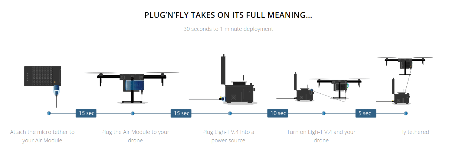
- Working with DJI M200,M210, M300 ( Air Module )
- Working with Elistair tethered drone solution – ORION
Ready for integration
Engineered to meet the most demanding missions with its rugged weather-resistant design, and compact modular metallic structure, the Safe-T 2 offers mounting plates and optional software development kit (SDK) for seamless integration into vehicles and fixed structures whilst also being agile enough for a single operator to deploy. Its interchangeable micro-tethers and smart adaptive winch control laws, allow the operator to reconfigure the station and use the best tether weight/power range for each drone.

Smart and Secured
The secure Dual-Comms option (Fiber optic and BPL), offers a redundant tethered data link, or the possibility to select which technology is best suited for the aircraft and/or payload. A patented Brake system also allows the user to adapt the maximal tether length, depending on the safety zone needed around the aircraft, for instance in urban or crowded environments. Like its predecessor, the Safe-T 2 integrates Elistair’s live flight management system with T-monitor mobile app offering optimal flight control for safer operations.

SAFE-T 2 Tethered Drone Station supplied with Air Module for DJI M200, M210 V2, M300
The Safe-T 2 has been built on the success of the flagship Safe-T product line which has been deployed in over 60 countries by governmental organisations, industrial groups, and security forces. The Safe-T 2 will take tethering operations to a new level.
Safe-T is a powerful tool, enabling drone operators to widen their perspectives by bringing unlimited autonomy, safety and real-time high resolution data transfer.
The solution gives access to a wide range of high value applications:
- Surveillance: events, forest fire management, harbors, anti-poaching
- Pop-up Telecommunications (4G, WI-FI, radio…)
- Traffic Management (camera or radar based)
- Industrial Inspection: Oil & Gas installations, Energy utilities, civil engineering structures
- Air quality monitoring
- TV Broadcast : Persistent live aerial coverage of sporting events, concerts and shows
- Lighting systems
- Anti-drone systems (drone detectors or jamming systems)
- Impact and Battle Damage Assessment (Fall of shot monitoring for artillery units)
Tethered Drones are proving to be extremely safe and fast to deploy for Defense, Telecommunications, Humanitarian Needs, Live Broadcast and Traffic Monitoring
LIGH-T 4
Unlimited Power, On The Move
Ruggedized Tethering Station for Drones
THE TETHERED STATION FOR ALL YOUR MISSIONS
Ligh-T V.4 is a ruggedized tethered drone station, offering extended possibilities for police forces, first responders and drone operators requiring a permanent aerial position.
Designed to withstand harsh transport conditions and deployable on any type of terrain, Ligh-T V.4 can be operational in seconds through its Dual Mode Tether Management.

LIGH-T V.4 is compatible with a wide range of drones thanks to its unique range of hot-swappable air modules.
LIGH-T V.4 is compatible with a wide range of drones thanks to its unique range of hot-swappable air modules.

Approved for Major Events Security
With the first version released back in 2015, Ligh-T has been widely deployed by police forces, public safety, private security and industries in over 50 countries, and was selected by for various major events such as the Superbowl 2019 held in Atlanta with CNN or Trinidad Carnival 2019 known as the biggest carnival in Caribbean.
With its experience and its large tethered drone customer base in more than 50 countries, Elistair proved itself capable of providing drones users with mission-critical and game-changing technology. Keeping up with its goals of flexibility, robustness and mobility, the Ligh-T V4 sees itself endowed with new features designed to facilitate operators’ workflow.
New Dual Mode Tether Management System Option
The French company released the V1 for the first time back in 2015. The V4, with its 70 meters (230 ft) long micro-tether, provides unlimited power to a wide range of drones thanks to Plug and Fly Air modules, such as DJI’s M200 V2, M200 V1, Inspire 1 and 2, or the Yuneec H920. Unlimited data transfer is possible through its 10.5 g/m (0.11 oz/ft) micro-tether.
The micro-tether is also equipped with a new Dual Mode Tether Management system (DMTM), enabling smart motorized control of the micro-tether tension while allowing the user to manually wind and unwind, in case of power outage for instance. Housed in a rugged cased with an open and accessible interface, the system is easily transportable, optimized for easy maintenance and fully protected from the elements, allowing it to be deployed quickly in the most demanding and challenging conditions.
Ready To Use & Rugged
It is the perfect plug-and-fly tool to have to ensure fast and safe surveillance, defense, public and private safety, incidents/natural disasters assessment and pop up telecommunication missions.
The smart system is completed by the T-Monitor application that allows a full monitoring of the drone tether station’s state during each flight.
The Ligh-T V4 has been thought, designed, manufactured and tested to meet the needs of operators seeking a modulable, ready to use and rugged tool.
Automated Motorisation
Ligh-T v.4 winch is now powered with a compact engine for secured tether unwinding
Mechanical Handle
For enhanced availability, your tethered system can be wound or unwound manually
ENHANCED FLIGHT DATA MANAGEMENT WITH T-MONITOR
Improved operational management through flight data recording
Understanding of equipment usage, display of flight statistics through detailed flight data
Overview of the tethered station and onboard battery status to monitor drone performance and ensure optimal operations
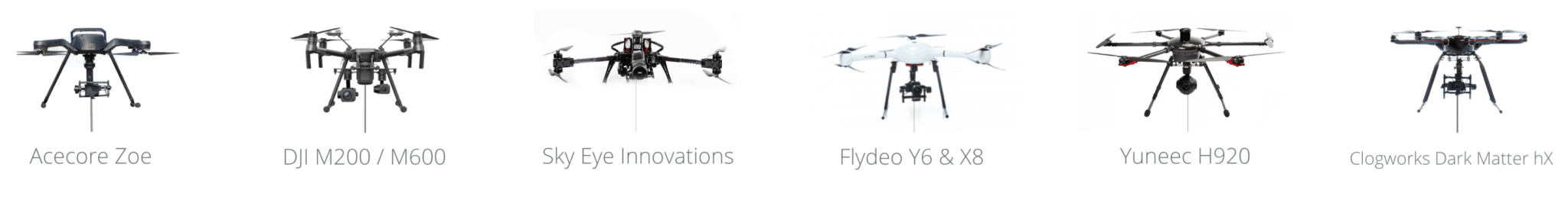
DJI Matrice 200 V.2
DJI Matrice 200
DJI Inspire 1
DJI Inspire 2
DJI S900
DJI Matrice 100
Yuneec H920
Acecore Zoe
Ligh-T is a powerful tool, enabling drone operators to widen their perspectives by bringing unlimited autonomy, safety and real-time high resolution data transfer.
The solution gives access to a wide range of high value applications:
- Surveillance: events, forest fire management, harbors, anti-poaching
- Pop-up Telecommunications
- Traffic Management
- Industrial Inspection: Oil & Gas installations, energy utilities, civil engineering structures
- Air quality monitoring
- TV Broadcast : Persistent aerial Lives on sporting events, concerts and shows
- Anti-drone systems (drone detectors or jamming systems)
- Impact and Battle Damage Assessment (Fall of shot monitoring for artillery units)


NEWS: Airscope is pleased to announce we are now officially working to promote Elistair Products in the region.


360 Panoramic - Client Area
Interactive 360° Degree Panorama Example
We can create 360° degree panoramas which are a unique view of a physical space. This form of interactive media is extremely powerful in giving an accurate spatial representation to the viewer. Our Interactive panoramas work on all media devices and can provide high-resolution virtual tours around sites from a bird’s eye view.

Drones for Progress Monitoring
Overview
Drones have become the go-to tool for construction firms to track, map, survey, inspect, and manage worksites more efficiently and safely.
Through aerial imagery and data, builders can map projects, report progress updates and gain insights through advanced analytics to make better, faster and more reliable decisions.
INCREASED SAFETY
REDUCED COSTS
EFFICIENT OPERATION
INFORMED DECISIONS
On-Site Progress
There’s an enormous amount of potential once construction gets underway – helping to track progress, keep tabs on materials, improving visibility and keeping sites safe. The data also provides a useful audit trail should problems arise and ensures any that do are dealt with as soon as they become known.
As the project moves to construction, drone users can keep an eye on assets and materials, more accurately gauge progress and completion and be confident in the quality of work based on highly accurate data, minimising the need for rework.
Drones also have benefits in keeping sites and workers safe and protected, spotting hazards before they occur, and adding to a wealth of information that reduces the likelihood of legal challenges

We use aerial drones for accurate surveying, monitoring construction sites for both progress and to quickly identify unsafe practices. Show your clients an aerial map or layout of an important construction project or simply to give them a current progress report within 24 hours.
How We Do It
By programming and automating our entire flight paths – including drone and camera movements, we are able to fly precisely the same flight over and over again. The resulting video and photographs allow for immediate and apparent evidence of construction progress on a weekly or monthly basis.
Specifications
• 4K UHD Video Filming
• 24 Megapixel Photography
• Computer controlled Drone & Camera movements
• Repeatable & identical each time
4 Videos taken on different Months.
NB – These videos are 10x the normal playback speed
What we can do
Showing The State of Progress
Most clients do not have the time to keep visiting an ongoing construction site, especially in the case of a 6-12 month project. Secondly, avoid having the client or investor disrupt the daily workflow by showing up onsite. Current on-the-ground pictures don’t always do the trick, so why not show your clients that you are now using the latest drone technology to document your progress reports?
Monitoring the Construction Site
Let’s face it, you have far too much work to be monitoring multiple job sites in any given day. Isn’t it time you took a bit of the load off and send up a drone to monitor weekly, bi-weekly or monthly progress on all your properties? We can provide you with a detailed video of the job site, any work standard or safety issues that may be going on and save you time, money and energy commuting from one job site to the next.
Inspection of Structures
Get detailed first-person-views of every detail including structure integrity, aesthetics, or even if something was installed off-plan. We can even stream the video down directly to a TV monitor onsite.
Improve Safety Records
With your projects recorded as the progress in Ultra Fine 4K video, you can discover an unstable infrastructure, or a labor or subcontractor that fails to show up on a given day, or document a discrepancy in the foundation as its being built. Our surveying and mapping can provide you and your clients with the images that can keep a project humming along with a proven safety record and help you maintain a stellar reputation.
Keeping Every Project On Track
Saving money and coming in on-budget is key to staying in business these days as a mechanical engineer or contractor. You need to determine right away if a project has gone sideways in order to prevent cost overruns. Let Drone Films LTD prevent accidents or damage, consistently monitor your job sites for abnormalities, and prepare you to move quickly on any budget overages or sub-standard work that could your project shut down.
Our Aerial progress videos and photography provide clients and project managers with up-to-date overviews of construction progress, preventing cost overruns and anomalies.
Aerial Photography
Construction site aerial photography is now being integrated into mainstream construction CAD software. Monthly progress photographs are being used to produce full 2d images that can be used for accurate measurement and use in conjunction with traditional quantity surveying methods.
Drone Photography Services see the applications where aerial photography drones (UAV’s) can be used cost effectively in the construction industry, and has been growing enormously over the past few years.
Images are now being used to create 3D meshes for building construction sites at key stages / milestones and these meshes are being integrated into the layers of CAD and construction project management software.
Aerial Photography
Our Creative Video Services can extend to full corporate films
Media
- High Resolution Photos up to 150 Mp
- High Resolution Videos up to 6K
- Photogrammetry Maps
- 3D Reality Models
- Volumetric Reports
- 360 Stitched Panorama photos
- 180 Stitched Panorama photos
Addons
- Custom Ai Detection
- 3D Reality Models
- VR View for Headsets
- Cloud Based Tools
- Volumetric Reports
- Video Editing
- Live Streaming View
Inspection
- Enable drone technology to be your bird’s eye view of your site
- Preserve a digital, visual record of your job site before decommissioning.
- Software provides built-in analysis and annotation tools to calculate area, volume, and distance accurately.
- Create 2D and 3D maps for accuracy and detail to resume operations quickly
- Geotag onsite tools, machinery, supplies, and assets
- Access and share your data, maps, and reports securely
Enterprise Class Technology
Airscope has enormous pride in it’s relentless pursuit of the best technology available.
We work with established and proven brands such as WORKSWELL, FLIR and UVIRCO for specialist sensors and software.
Maritime and Off-Shore
Drones for the Maritime Industry
Oveview
Airscope provides a growing number of applications in the maritime sector which significantly contribute to safety and risk management
INCREASED SAFETY
REDUCED COSTS
EFFICIENT OPERATION
INFORMED DECISIONS
Multiple Applications and Services
Airscope drone services offer class societies and marine surveyors the ability to physically examine ships and cargo.
Loss adjusters can benefit from our inspection flights with high resolution zoom cameras to assess damage to vessels and assess marine claims, while operators can assess the condition of assets, such as oil rigs, pipelines and offshore turbines.
Our drones at height can be employed to carry out inspections and help with any form of reporting required to assess the structural integrity of a vessel or to monitor the loading of cargo.
Precision Inspection and Survey
Airscope provides drone services for assessing structures such as piping, access points, equipment, and safety systems for coating condition, corrosion, and damage.
By using our UAV technology, surveyor safety is improved and survey times and staging costs associated with visual condition checks of remote structural components can be significantly reduced.
Inspections of ship tanks using our unmanned systems avoids high costs, time consuming, and potentially dangerous operations.


Drones used for inspections of cargo tanks and holds, where enclosed cargo holds many contain noxious gases avoids a risky task for crew. Easy and quick analysis determines the safety of tanks entry saving lives with just a matter of minutes of drone flight.
The Benefits of UAVs in Marine Survey/Shipping
- optimize maintenance while increasing safety in operation
- identify and forecast maintenance requirements prior to failure
- reduce environmental impacts and operational costs
- identify if human access and inspection is required
- quick overview and evaluation of hard to reach areas
- the highest level of precision and autonomy
- Real-time data for fast analysis with built in measurement tools
- fast, efficient, reliable and shareable data
- preventive maintenance planning and optimized production
- access to areas that pose health, safety and environmental risk to humans
- Realtime high quality images and video.
30X zoom capability provides sharp and detailed video and photographs of defects - quick on-site deployment
- reduced downtime.
ROVs offer an easy, fast and effective way to perform hull inspections, dock inspections and virtually any task that requires immediate eyes under the water
Hull Inspsection
A vessel’s structural integrity, potential transferring of invasive species, or contraband smuggling demands periodic inspections of the vessel’s hull during transit and when entering port.
Our commercial grade ROVs provide an affordable, user-friendly way to perform marine surveys, ship inspections, and more without diver intervention.
ROVs offer an easy, fast and effective way to perform hull inspections, dock inspections and virtually any task that requires immediate eyes under the water.
Emergency hull inspections, nighttime inspections, ballast tank inspections, and marina checks are easily completed with Deep Trekker remotely operated vehicles. Boat, yacht or vessel owners now have a way to monitor the status of their hull without needing to dry dock it or send divers into unknown areas. This in turn gives them the opportunity to address any potential issues at the outset, avoiding higher repair costs and further damage to one’s hull. If an ROV boat inspection reveals any damage, you will know exactly where to send your repair team.
The ROV’s spherical shape and patented pitching system allows you to effortlessly maneuver it into tight spots. The internal battery power prevents the need for excessive cord management, which further simplifies the ROV’s operation. What’s more, the lack of the need for connectivity to a generator or topside box means you can deploy the ROV from anywhere on the vessel or docks — even in the most remote locations. In addition, we have several ROV attachments available, such as a thickness gauge, which allow you to see specific measurements about your vessel.

Using a camera on remote controlled underwater vehicles to perform hull inspections provides a cost-effective preventive maintenance step that can not only inspect current problems but also detect signs of minor hull damage before it can become a serious issue.
One of the biggest benefits of using a remote operated underwater drone can be the early detection of potentially destructive hull corrosion.
The Benefits of ROVs in Marine Survey/Shipping:
- Avoid unnecessary down time in deploying a dive team or lifting out of water
- Easily inspect areas too small for divers
- 270 degree camera rotation to quickly view the bottom of the hull
- Optional side-facing cameras to reduce inspection time
- Record all inspections with voice-over to SD Card
- Sophisticated add-ons such as Thickness Gauge and Sonar
Submersible Multi-function Vehicles
The Utility Crawler is the most versatile inspection vehicle of its kind. The sleek, three-wheel submersible comes with a magnetic option, creating the ideal vehicle for an array of underwater work. Compact for transportation and extremely portable, our Utility Crawlers have been designed to launch immediately for any location, and with the efficiency of internal batteries, they can provide up to 8 hours of work in a single 1.5 hour charge.
Able to work underwater up to 50m (164ft), all with live video streaming to the surface. The Utility Crawler is our tool for a multitude of remote inspections, with application-specific add-ons for photography, video, pressure washing, vacuuming, thickness testing, and more – both above and below the water.
Skidless steering and zero turning radius allow the utility crawler to maneuver in tight areas and tough surfaces. Rare earth magnets allow the drone to climb in almost any direction on ferrous materials.

The Utility Crawler is capable of Metal Thickness Testing using a Cygnus Thickness Gauge for areas of interest on ship hulls or structures to ensure their integrity.
Benefits:
- Measures remaining metal thickness on corroded and coated structures
- All measurements are error checked using 3 return echoes to give repeatable, reliable results
- Accepted by all major classification societies
- Greatly reduces inspection time and costs
- Echo strength indicator to aid measurement.
Ideal Applications:
- Tanks, Internal and External Inspections
- Underwater Infrastructure Inspections
- Vessel Hull and Ballast Tank Inspection
Panoramic Drone Photography
Drones for Panoramic Photography
Interactive 360 Photographic Panorama example. Click on the Arrows in the top right of the image to make Full Screen.
Interactive 360 Degree Panoramic Photography
We can create 360 degree panoramas which are a unique view of a physical space. This form of interactive media is extremely powerful for giving an accurate spatial representation to the viewer. Our 360 Panos can offer high-resolution virtual tours around sites from a bird’s eye view.
Panoramic Stills Photography
Airscope Panoramas require precision photography to capture high resolution photos that can be stitched in our special software.
The images we take are seamlessly merged together and create a much larger photographic view than is possible through normal lenses.
Airscope Panoramic Photography is essential to gain the wider view at any stage of construction.
Bespoke Drones
We don’t just fly drones, In our R&D workshop we can build them too. Whether it is a novelty drone for a PR stunt or for a very specific industry purpose we can manufacture a bespoke drone to your specifications.
Airscope is ready and able to create whatever type of UAV system you require.
Please contact us for more information
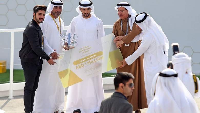
Airscope’s CEO and founder of SANAD Academy, Mohammad Aziz won the prestigious ‘Drone for Good’ in 2017
Take a look at the video below, where our CEO Mohammed Aziz and Chairman Mansour Al Blooshi spoke about the birth of the idea to create the first intelligent, safe, flying rescue ring of its kind:

PRESS

Take a look at the finalists of the UAE Drones For Good Award – a competition dedicated to transforming innovative drone technologies into practical, realizable solutions for improving people’s lives.
The UAE Drones For Good Award is a year-long competition organized by the United Arab Emirates Telecommunications Regulatory Authority and Information and Communication Technology Fund.
Launched in 2014, it aims at encouraging useful and positive applications for drone technology and, with a significant prize of $1 Million for the international winners and UAE Dhs1 million for the UAE winners, it’s the largest competition of its kind.
The 2017 edition of this competition, sponsored by Dubai Internet City, Samsung, Digi Robotics, and MakersBuilders, attracted over 1,000 contestants from 165 different countries and the 40 best local and international teams were shortlisted for the awards.
The Finals were held in the technology park Dubai Internet City on 17-18 of February 2017.
Practical and innovative solutions ranged from traffic control and smart oil-spill solutions to drones for rapid evacuation.
His Highness, Sheikh Hamdan bin Mohammed bin Rashid Al Maktoum, Dubai Crown Prince, reviewed projects and technologies of the participating teams and honored two teams as the winners: Sanad Academy’s Smart Ring and Nokia Saving Lives.
Winner (UAE Competition): Smart Ring by Sanad Academy
Sanad Academy is the United Arab Emirate’s first Remotely Piloted Aircraft training and certification specialists endorsed by the Dubai civil aviation authority.
Their team won the UAE 1Dh million prize in the national category with their invention “Smart Ring”, a drone capable of locating drowning victims and offering immediate assistance.
“Smart Ring” is a fully waterproof, amphibious system, infused with innovative drone technology within its body, enabling GPS positioning and radio communication features.
And the best part is, according to Mohammed Aziz:
“You do not need a lot of skill to use it, it can be used through the mobile app. The drone can fly, but also can go to the victim in the water and save them. You can also have multiple rings sending signals to each other”.
Safe
Safety is our primary concern, due to which we make sure, that our team is highly qualified and always perform risk mitigation prior to any project.
Certified
Certified internationally by the FAA as well as all local civil aviation authorities in the United Arab Emirates, we ensure that all aspects of legality are covered.
Insured
All of our aircraft have liability insurance of up to $1,000,000 in third party coverage in case of an unforeseeable event or natural disaster.

Underwater Inspections with ROV Drones
Drones for Underwater Inspections
Overview
Reliable and Durable, our underwater viewing devices can serve a wide variety of valuable purposes for industries such as aquaculture, infrastructure, energy, military/security/police, shipping, commercial and salvage diving and underwater discovery. Examples include:
Infrastructure maintenance
Municipalities and service companies can use the ROV’s underwater remote camera to perform frequent inspections of stormwater/drain pipes, water tanks, sewer pipes, etc. to ensure the piping systems are functioning properly and are free of damage. Our ROVs are perfect for situations where powerful and portable underwater imaging is needed.
Video recording & streaming
ROVs record events in a specified area. This underwater video system can be beneficial for activities such as monitoring aquatic wildlife, conducting academic research or maintaining security at an undersea drilling platform or port. In addition, ROVs stream live video to the surface while being operated manually.
Hull inspections
Using the camera on our remote controlled underwater vehicles to perform hull inspections provides a cost-effective preventive maintenance step that can detect signs of minor hull damage before it can become a serious issue. One of the biggest benefits of using a remote operated underwater drone is the early detection of potentially destructive hull corrosion
Fishery/Aquaculture
Commercial fisheries and aquaculture farms can make use of our underwater observation ROVs for tasks such as inspecting predator nets for damage, inspecting mooring lines and other submerged infrastructure, monitoring fish health, feeding and behavior. Our unique mort retrieval tool provides a simple means of collecting a mort to perform diagnostics or aid the lift-up system.
Underwater Bridge Inspections with ROV Drones
Remotely Operated Vehicles (ROV), or underwater drones, are establishing themselves as the ideal tool for underwater bridge inspections.
With the public safety in mind and to continue the flow of traffic, these overpasses must be monitored on a consistent basis. Evaluating the overall architecture on the surface for any signs of damage or deterioration which, includes underwater bridge inspections

The entire submerged exterior of the bridges’ piers and abutments are surveyed for signs of erosion, destruction, visual signs of distress, and to examine the scour.

Commercial Divers & Their Safety
Traditionally, commercial divers undergo the task of underwater bridge inspections. For employee safety, teams of three or more divers navigate below the water to not only inspect the bridge’s edifice but also monitor the other divers’ security.
Given the variety of environments, unsafe situations often keep divers out of the water. At times, the visibility within the water is low or after an object collides into the structure, divers must examine the damage through the scattered wreckage. In this instance, a couple different options present themselves: acoustic imaging or Remotely Operated Vehicle inspections.
ROV innovations have become synonymous with underwater asset inspections, specifically with assets in zero visibility water.
Working with ROV Technology
Rather than sending a team of divers to conduct underwater bridge inspections, commercial diving companies and municipalities send the drone below the surface first. Remotely Operated Vehicle versatility allows for acoustic imaging integration; giving the opportunity to survey the area for any obstructions or potential threats to the repair team and to give an overall picture of the integrity of the structure.
The underwater drone’s construct with 4 vectored thrusters gives it the ability to move laterally; this is specifically important in bridge inspections. The ROV is able to work against currents and hold its position facing the piers or other areas of interest.
With a unique pitching system, an ROV boasts unmatched maneuverability. Coupling with the 330-degree field of view with the rotating HD camera, the ROV proves to be the ideal solution to underwater bridge inspections. This inimitable construction allows the ROV to hold its position and scan entire area using the imaging sonar.
Once the inspection is complete revealing areas of interest, repairs to the structure may begin using commercial dive teams. The underwater drone acts as the supervisor on-site; from the surface, the ROV operator monitors the diver’s progress and safety through the live video feed on the controller. Additionally, the video feed can be recorded or captured as a still frame; as a result, this provides the opportunity to archive inspections for later review or to present to clients the before and after.
For its versatility, robustness, and portability, the ROV continues to establish itself as the ideal tool to complete underwater bridge inspections

Acoustic Imaging
ROVs can use acoustic imaging if required for strategising of diving operations by identifying areas damage; giving divers an area to concentrate their repair efforts. Moreover, acoustic imaging provides foresight to potential dangers in the water prior to sending in the dive team.

Enterprise Class Technology
Airscope has enormous pride in it’s relentless pursuit of the best technology available.
We work with highly established and proven brands

Reality Modeling
Drones for Reality Modeling

Overview
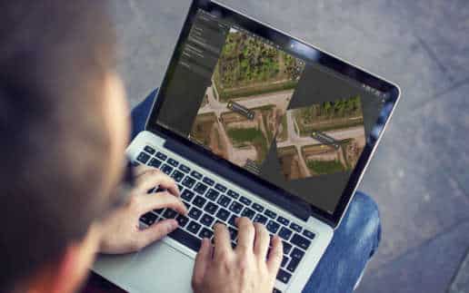
Many existing structures have no information model, no accurate records, possibly some unreliable or outdated 2D drawings. If you are operating in an existing plant for instance with poor engineering records, we can now capture a precise 3D model using digital photographs taken from unmanned aerial vehicles to render an information model that you can maintain going forward.
Creating 3D Asset Drawings
To model a given asset, the aerial image acquisition process requires sharp overlapping photographs to capture imagery datasets which are used to not only observe current state but also to compare them to the model as time goes on.
Once the 3D models are created, they can be used to improve the construction of new facilities as well as in ongoing operations. Recurring 3D reconstruction will support inspection processes, and will allow engineers and designers to work on a 3D model that is always up to date for their enhancement or maintenance plans.

Drones and reality modeling should be a part of every maintenance organization and every proactive maintenance workflow to dramatically enhance productivity and safety in infrastructure asset inspections.

Conducting Inspections in Out of Reach Areas
From structural integrity issues on bridges and roads, to wind turbine blades, rig inspections, pipeline monitoring for wall thickness, welds, corrosion and other structural integrity issues, unmanned aerial vehicles with mounted cameras are helping maintenance to more easily and cost-effectively observe these out-of-reach conditions.
Bridge and road inspections, especially as regulatory guidelines move towards reliability-based inspection practices, will require flexibility as the frequency of inspections changes based on operating context. Water and power utilities are benefiting from unmanned drones using high definition sonar to conduct subsea inspections. All in all, the use of drones can make what used to be a difficult and costly task, easier and more cost effective.
Drones and reality modeling can and should be a part of every maintenance organization and every proactive maintenance workflow to dramatically enhance productivity and safety in infrastructure asset inspections.
Reporting & Communication
Airscope makes it possible to visualize your 3D model at any given moment in time and communicate effectively with stakeholders. The result is reduced site visits; saving you time, money, and helping to keep people safe.
From our 3D Reality models, measurements can also be exported into tables and all major GIS software packages including ArcGIS, CAD & Bentley.


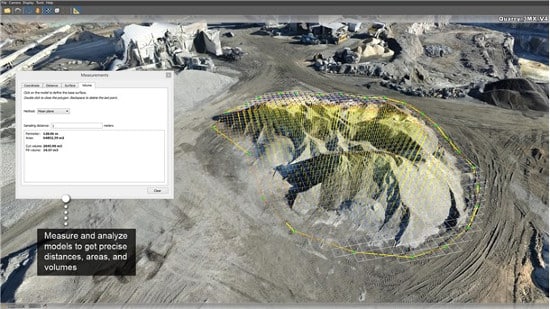
Drones in Mining
The mining sector is beginning to realize substantial savings from speed and value that drone survey provides. A volumetric survey of stockpiles and cut and blast points can provide actionable information within hours, ensuring that inventory is accurate, and pit and dump management is optimal.
The use of drones in mining operations can further add value to:
• Damage Assessment
• Up-to-date surfaces for optimizing blast design
• Stockpile management
• Drainage management
• Ongoing progress monitoring and reporting
• Haul-route optimisation
Terrain modelling
Drones allow for terrain to be mapped quickly, safely and cost effectively.
With a single automated flight, a drone can collect timely, geo-referenced imagery that is quickly transformed into a precise 3D copy of your site
Accurate Elevation Models
Elevation model creation and data that can be imported into most BIM and 3D modelling software for analysis and manipulation by your in-house teams.
Stockpile Reporting
Highly accurate volumetric analysis of stockpiles with significantly lowers risks to surveyors as they are no longer required to span mining sites and climb stockpiles in order to perform inspections.


Enterprise Class Technology
Airscope has enormous pride in it’s relentless pursuit of the best technology available.
We work with established and proven brands such as WORKSWELL, FLIR and UVIRCO for specialist sensors and software.


Renewable Energy

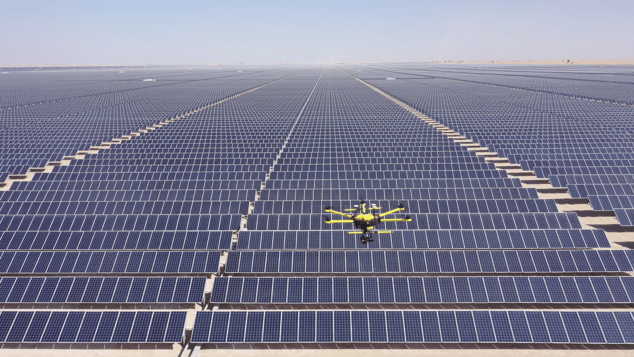
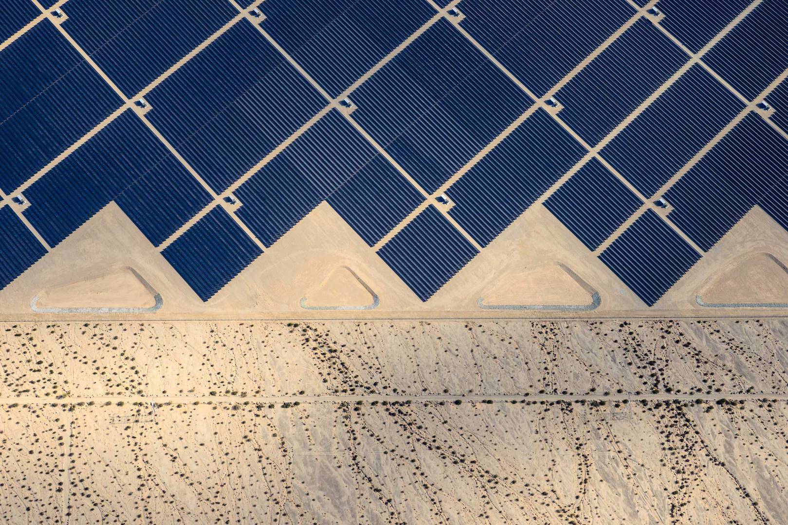
Drone Solar Panel Inspection in Dubai
With over 300GW of capacity in the world, and ever-increasing efficiency, solar technology offers an inexhaustible power source.
Thermodiagnosis of photo voltaic cells ensures that hot spots caused by damage or misalignment show up readily to the viewer. Our specialist thermal imaging drones can cover an entire solar field in hours, combining multiple sensors for visual and thermal inspection.
Our cloud based Asset Management Software provides survey grade accuracy, detailing module faults, string faults, racking and balance faults and temporary shadowing issues are presented to our clients within hours of completing a thermal drone survey.
Multiple Benefits and Applications of Our Drone Thermography Services
Airscope drone services offer class societies and marine surveyors the ability to physically examine ships and cargo.
Loss adjusters can benefit from our inspection flights with high resolution zoom cameras to assess damage to vessels and assess marine claims, while operators can assess the condition of assets, such as oil rigs, pipelines and offshore turbines.
Our drones at height can be employed to carry out inspections and help with any form of reporting required to assess the structural integrity of a vessel or to monitor the loading of cargo.

Airscope – Leading Providers of Drone Thermal Inspection Services
Airscope is a leading drone company in the UAE with many years of experience and unparalleled expertise in providing drone filming solutions and drone solar panel inspection services.
We provide hi-tech, cutting-edge drones powered by the most advanced technology and radiometric thermal cameras for the inspection and remote inspection of solar panels to collect the necessary data efficiently and accurately.
Affordable and High Quality Drone Inspection of Solar Panels with Comprehensive Data Reports
At Airscope, we provide the best drones for solar inspection to survey solar panels that are not easily accessible, such as on building rooves, where manual inspections and surveys of are both time-consuming and risky. Our drone thermography services negate all these issues and present comprehensive and detailed inspection reports to our clients in a quick and efficient manner.
Moreover, we provide thermal inspection solutions to leading energy industries in the UAE at market-competitive prices and carefully design these solutions while keeping the requirements and budgets of our clients in mind.
Contact Us Today!
Find more information about our drone thermography services by getting in touch with us at +971 (0)4 423 4982 or send us an email at info@airscope.io.
The accessibility and capability of the mission-critical data gathered for asset integrity inspections has been a game-changer for the renewables industry.

Enterprise Class Technology
Airscope has enormous pride in it’s relentless pursuit of the best technology available.
We work with established and proven brands such as WORKSWELL, FLIR and UVIRCO for specialist sensors and software.
Agriculture

Precision Agriculture
The use of autonomous drones for precision agriculture increases crop yields by identifying problems that are not visible to the naked eye. Our custom-built agricultural drone allows us to deploy and photograph fields using multispectral cameras. By processing these images with specialist software, slight variations are made more visible, which when combined with ground truthing allows our clients to identify problems with irrigation, fertilizer distribution & plant health.
GPS assisted drone photography allows us to deliver highly accurate maps, allowing for pinpoint accuracy in identifying problem areas.
A Game Changer for Agribusiness
Agricultural drones represent a new and much faster way to collect field data. The most compelling reason for using agriculture drones is that data is on-demand; whenever and wherever needed, agricultural drones can be easily deployed to gather up-to-the-minute information. These crop drones in the growing fields today are back-of-the-truck equipment, bringing advanced growers crucial information faster than ever before.
Agricultural drones permit better-than-satellite information on demand. Analyzing images with Normalized Difference Vegetation Index (NDVI) algorithms yields extremely accurate crop mapping, all without pilots, planes or satellites. Multiple sensor studies produce perfectly focused data, too, as RGB, red edge, near infrared and other spectral analysis tools can reveal crop health and maturity, soil moisture and environmental stress when and as required.
Especially in comparison with flight operations, agricultural drones provide highly specialized and detailed data at a significant cost savings, allowing operations to expand monitoring and analysis in a big way. Notably, drone operation has also become fairly simple thanks to self-guided flight. Current drone models are proving sturdy and reliable in the field as well, making them easy to integrate into the crop-scouting workflow. Field missions become highly time efficient, too, as agricultural drones are “launch and forget” tools, allowing management to multitask while the drone works on a robotic program.
A simplified process:
Initial Survey
Defining the edges of each field for the drone nav system by GPS is the basis for every operation. Once done, flight parameters are uploaded to the drone via wireless link. Surveys are only required for the first flight and are saved to the on-board system.
Flight
The agricultural drone launches and executes the full survey flight automatically, returning to the start point to land.
Upload
After a round of flights, upload the information for data processing.
Analyze
Within hours, you’ll get an email alert; your results are available for viewing and download.
Normalized Difference Vegetation Index (NDVI) algorithms yield extremely accurate crop mapping when combined with Powerful Software such as Pix4DFields
Enterprise Class Technology
Airscope has enormous pride in it’s relentless pursuit of the best technology available.
We work with established and proven brands such as WORKSWELL, FLIR and UVIRCO for specialist sensors and software.
Drones for Waste Management
Industrial Pages
Overview
Drones are offering the waste industry innovative new ways of reducing costs, increasing accuracy of data collection, and providing greater oversight and efficiency in landfill assessment.
INCREASED SAFETY
REDUCED COSTS
EFFICIENT OPERATION
INFORMED DECISIONS

Highly accurate 3D models can provide volumetric analysis of areas that are hazardous to inspect from the ground, improving site safety while also allowing operations to continue while the survey is being conducted, resulting in reduced downtime.
Mapping of Landfills
Landfill managers are required to patrol their sites on foot regularly to address potential hazards that tend to increase in landfills. But landfills are massive and difficult to maneuver. With aerial access from drones, managers no longer have to hike through unstable terrain. In general, drone mapping of landfills has proven to be more time-efficient and less laborious.
With photos and videos captured by drones flying smoothly over the terrain, managers can analyze the landfill topography. This is then used to study the critical points of potential threats at the location, from examining the stability of the slope to tracking gases that can escape and can cause explosions.
Additionally, drone image mapping is made more accurate than manned surveillance using 3D models built from 2D aerial shot images. These models are useful as drones not only save the physical drag that landfill managers use to assess the landfill site, but also provide a more accurate and successful site inspection
Airspace Management
Volumetric analysis of cells can generate airspace calculations in seconds. Periodic surveys can increase the life of cells by tracking compaction rate over time.

Drone mapping saves time and money by providing a detailed overview of their sites in a fraction of the time it takes to do ground inspections.

Compliance Reporting
Airscope offers a cost effective way to collect the data needed to calculate current, changed and remaining airspace for your compliance reports.
Measurements can also be exported into tables and all major GIS software packages including ArcGIS, CAD & Bentley.
Thermal Landfill Mapping
In landfills, biogas is generated from waste mixtures, which can be explosive. To curb this situation, UAVs can be used to detect abnormal temperatures to prevent potential emergencies. The drone can fly over the landfill and scan areas with a thermal imager. These cameras analyze the thermal changes within set perimeters of the landfill. Landfill managers use this data to determine the potential risks of explosion and fire.
Thanks to the thermal imaging cameras installed, drones are even more reliable in detecting thermal anomalies than terrestrial thermal imaging. They measure many thermal statistics in real time and immediately send feedback. These drones bring added value to thermographic inspection of landfills

Inspection
- Quick deployment, with easy access to areas otherwise difficult to enter on the ground
- Improved safety in dangerous areas such as the receiving pit at a waste-to-energy plant or transfer station
- Building & Roof Inspections
- Inspection of the earth dikes or outfalls at large leachate or wastewater treatment ponds
Topographic Survey
- Repeatable surveys allow the the monitoring of landfill progress over time
- Tracking the size or location of a landfill work site
- Monitoring the quality and health of plant growth over landfill using NDVI survey
- Volumetric Analysis
Safety
- Monitoring of gradients on earthworks
- Monitoring house keeping
- Assessing an accident in which hazardous materials are involved and access to the accident site is difficult
- Use of an infrared camera to spot sub-surface fires
Enterprise Class Technology
Airscope has enormous pride in it’s relentless pursuit of the best technology available.
We work with established and proven brands such as WORKSWELL, FLIR and UVIRCO for specialist sensors and software.
Oil and Gas
Drones for Oil and Gas
Overview
Using industry grade UAV systems we are able to conduct close range remote visual and thermal inspections and surveys at live unreachable structures onshore and offshore. Remote operations significantly reduce costs of downtime while increasing safety.
INCREASED SAFETY
REDUCED COSTS
EFFICIENT OPERATION
INFORMED DECISIONS
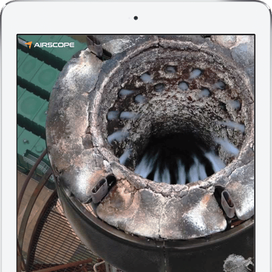
Internal Tank Inspection
Using a fully protected and caged aircraft, we are able to perform internal inspections on operational vessels and tankers such as bulk carriers and oil storage tanks as well as other confined spaces such as chimney stack and thermal boilers. This reduces the risk of labour working at heights and dangerous confined spaces.


Live Flare Stack Inspection
Remote inspection using UAV systems allows operation while the flare is live and online, therefore avoiding the requirement to shutdown. This saves millions of dollars per inspection as an online inspection, 4-6 months before a shutdown, provides the information to fully plan, budget or postpone shutdowns and turnarounds, removing risk and leading to further cost savings.
Underdeck Inspection
Our user-friendly online platform makes it possible for companies to improve their workflows through rapid data processing and real-time sharable drone maps and 3D models with built in measurement and analysis tools. Accurate & rapid drone surveys combined with our online data sharing platform allows for project monitoring with built in measurement & analysis tools and data sharing.

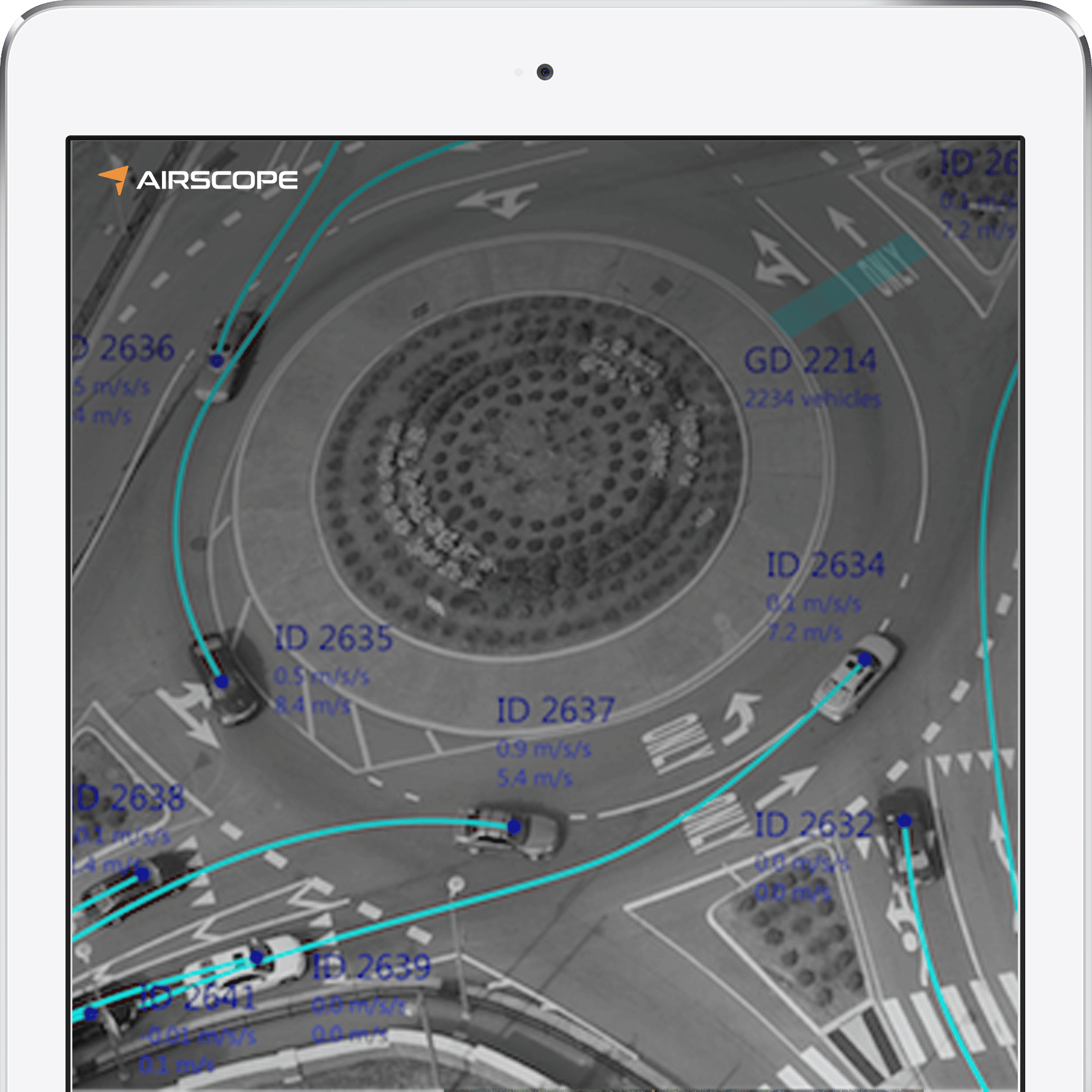
Urban Planning
Overview
Unmanned Aerial Systems have proved to be a great inspections tool for infrastructure assets and urban planning. It allows quicker mobility while increasing safety and efficiency. From under deck bridge inspections, to traffic monitoring, we are able to provide a wide array of services using our industrial drones along with powerful AI integrated software.
INCREASED SAFETY
REDUCED COSTS
EFFICIENT OPERATION
INFORMED DECISIONS

Software
Using powerful software, we are able to convert aerial data to meaningful and valuable information that can help with infrastructure planning.
• Count vehicles at intersections
• Measure speed and acceleration
• Measure emissions and air quality
• Identify vehicle classification

Bridge Inspection
Drones for Bridge Inspection
Underdeck Inspection
Close proximity, remote underdeck inspection allows a much safer and quicker operation than traditional methods such as scaffolding or rope access. This allows multiple remote operations in less time, helping quicker decision making.
INCREASED SAFETY
REDUCED COSTS
EFFICIENT OPERATION
INFORMED DECISIONS

Corrosion and Faults
Using powerful 10x zoom lenses onboard our aerial platforms, we are able to capture high resolution data from a very close proximity, do inspect for corrosion, faults or damage.
Reduced Costs
Remote inspections avoid the need of road closures and night time operations. It is also quicker than traditional methods, thereby reducing inspection costs significantly.
Increased Safety
Electric UAV systems are much safer as they remove the need for road side operation and is also safer than traditional methods such as rope access.
Quick Deployment
Traditional methods such as rope access and scaffolding are costly and time consuming. Using UAV systems, we are able to operate remotely without any time consuming set up.
Enterprise Class Technology
Airscope has enormous pride in it’s relentless pursuit of the best technology available.
We work with established and proven brands such as WORKSWELL, FLIR and UVIRCO for specialist sensors and software.